In daylight our big blue marble is all land, oceans and clouds. But the night is electric.
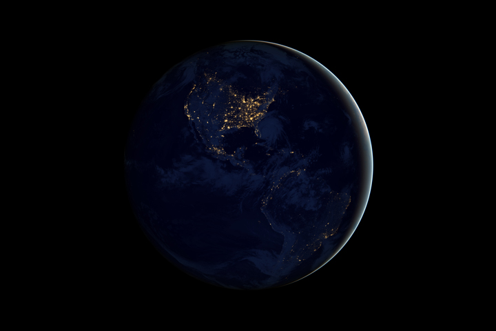
This image of North and South America at night is a composite assembled from data acquired by the Suomi NPP satellite in April and October 2012. The new data was mapped over existing Blue Marble imagery of Earth to provide a realistic view of the planet.
The nighttime view was made possible by the new satellite’s “day-night band” of the Visible Infrared Imaging Radiometer Suite. VIIRS detects light in a range of wavelengths from green to near-infrared and uses filtering techniques to observe dim signals such as city lights, gas flares, auroras, wildfires, and reflected moonlight. In this case, auroras, fires, and other stray light have been removed to emphasize the city lights.
Although the view looking down from space is of a sparkling show, the downside of course is light pollution over major metropolitan areas which impede the view of the night sky from the ground. (Find out more at the International Dark Sky Association site.)
Read more (and watch a video of these nighttime images of Earth) below:

“Artificial lighting is a excellent remote sensing observable and proxy for human activity,” says Chris Elvidge, who leads the Earth Observation Group at NOAA’s National Geophysical Data Center. Social scientists and demographers have used night lights to model the spatial distribution of economic activity, of constructed surfaces, and of populations. Planners and environmental groups have used maps of lights to select sites for astronomical observatories and to monitor human development around parks and wildlife refuges. Electric power companies, emergency managers, and news media turn to night lights to observe blackouts.
This video uses the Earth at night view created by NASA’s Earth Observatory with data processed by NOAA’s National Geophysical Data Center and combined with a version of the Earth Observatory’s Blue Marble: Next Generation.
See more images and videos here: http://earthobservatory.nasa.gov/NightLights And for a really cool interactive map of the Black Marble images, go to the NASA Worldview site here.
NASA Earth Observatory image by Robert Simmon, using Suomi NPP VIIRS data provided courtesy of Chris Elvidge (NOAA National Geophysical Data Center).

Looking so beutiful
LikeLike
These nighttime images of Earth on the video sound to me a little magic.
Jeff Barani from Vence (France)
LikeLike
Re-blogged this post on Gunsmoke and Knitting. Thanks!
LikeLike
There is something very wrong with this. There are no towns in the middle west side of Australia. Look it up on google.
LikeLike