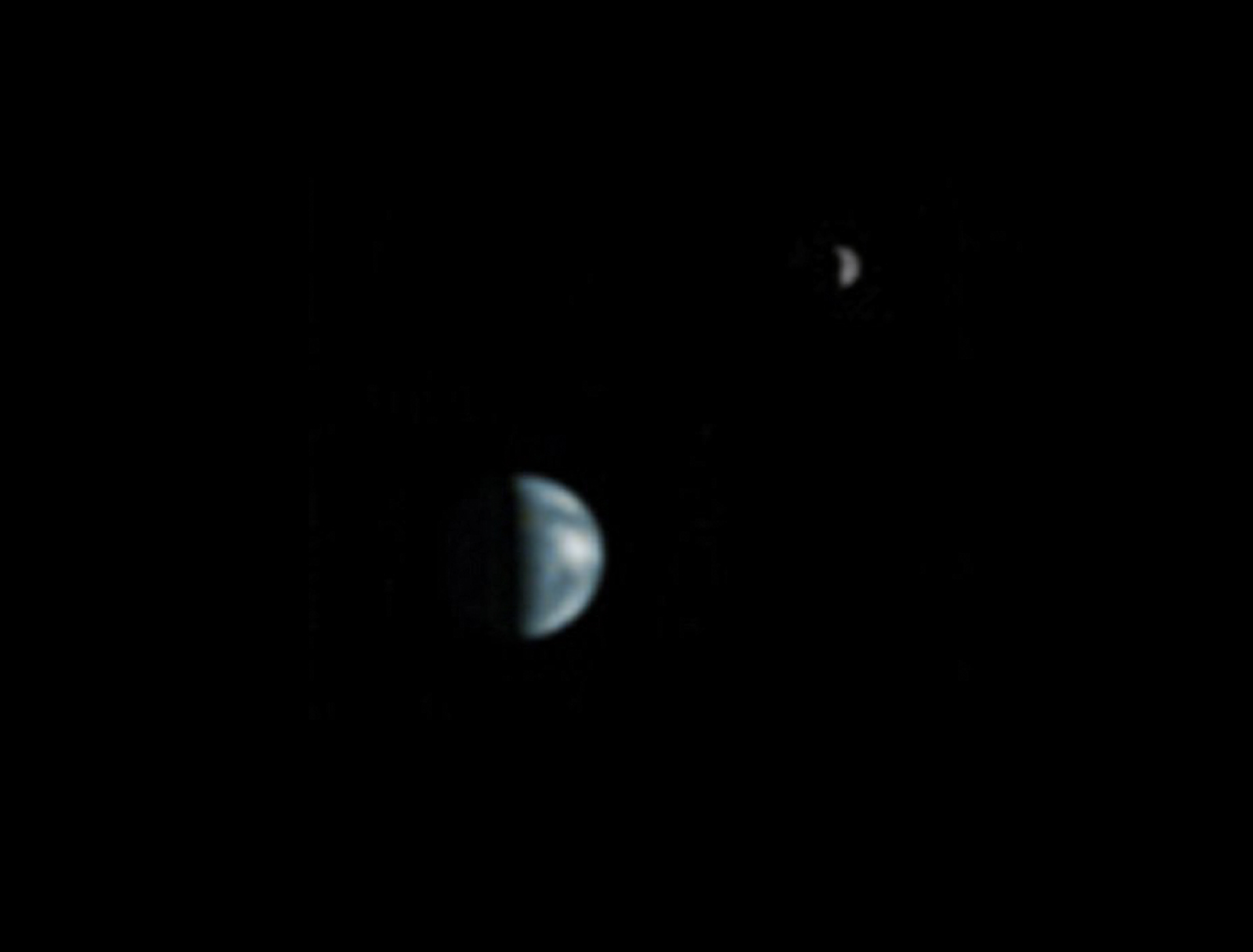
This is an image of Earth and the Moon captured from Mars by the Mars Orbiter Camera (MOC) aboard NASA’s Mars Global Surveyor on May 8, 2003. It was the first time an image had been captured from another planet—i.e., by a spacecraft in orbit—showing both bodies as discernible planetary disks, in phases. At that time Mars and Earth were 86.9 million miles / 139.8 million km apart.
From NASA:
This is the first image of Earth ever taken from another planet that actually shows our home as a planetary disk. Because Earth and the Moon are closer to the Sun than Mars, they exhibit phases, just as the Moon, Venus, and Mercury do when viewed from Earth. As seen from Mars by the NASA Mars Global Surveyor on May 8, 2003, at 13:00 GMT (6:00 a.m. PDT), Earth and the Moon appeared in the evening sky.
This Earth/Moon image has been specially processed to allow both Earth (with an apparent magnitude of -2.5) and the much darker Moon (with an apparent magnitude of +0.9) to be visible together. The bright area at the top of the image of Earth is cloud cover over central and eastern North America. Below that, a darker area includes Central America and the Gulf of Mexico. The bright feature near the center right of the crescent Earth consists of clouds over northern South America. The image also shows the Earth-facing hemisphere of the Moon, since the Moon was on the far side of Earth as viewed from Mars. The slightly lighter tone of the lower portion of the image of the Moon results from the large and conspicuous ray system associated with the crater Tycho.
A note about the coloring process: The Mars Global Surveyor Mars Orbital Camera (MOC, a high-resolution camera) only takes grayscale (black-and-white) images. To “colorize” the image, a Mariner 10 Earth/Moon image taken in 1973 was used to color this Earth and Moon picture. The procedure used was as follows: the Mariner 10 image was converted from 24-bit color to 8-bit color using a JPEG to GIF conversion program. The 8-bit color image was converted to 8-bit grayscale and an associated lookup table mapping each gray value of the image to a red-green-blue color triplet (RGB). Each color triplet was root-sum-squared (RSS), and sorted in increasing RSS values. These sorted lists were brightness-to-color maps for the images. Each brightness-to-color map was then used to convert the 8-bit grayscale MOC image to an 8-bit color image. This 8-bit color image was then converted to a 24-bit color image. The color image was edited to return the background to black.
Mars Global Surveyor, launched in 1996, operated longer at Mars than any other spacecraft in history, and for more than four times as long as the prime mission originally planned. The spacecraft returned detailed information that has overhauled understanding about Mars. Major findings include dramatic evidence that water still flows in short bursts down hillside gullies, and identification of deposits of water-related minerals leading to selection of a Mars rover landing site.
After studying Mars four times as long as originally planned, NASA’s Mars Global Surveyor orbiter succumbed to battery failure on November 2, 2006 caused by a complex sequence of events involving the onboard computer memory and ground commands.
Note: the image has been slightly color- and contrast-adjusted, digitally upscaled to 1600 x 1200 to and had its black area expanded by me. — JM

That’s no moon.
LikeLiked by 1 person
It’s a movie set
LikeLike